First let's go over some basics. From the meteorological perspective, one can think of pressure as the amount of air mass above a point (gravity provides the acceleration). So high pressure means relative large amounts of air mass above a point and low pressure means a relatively low amount of air mass above a point.
Now, think of two columns of air that start at surface and go into space. One column is really cold and the other column is really warm. Warm air is less dense than the cold air. If the cold air column and the warm column have the same amount of mass, the warm air column will be taller. If the two columns have the same mass, the surface pressure of the two columns will be the same.
If we travel up these two columns we would expect the pressure to decrease with them as the amount of mass above us decreases. The pressure in the cold column would decrease faster than the mass in the warm column as we travel up the columns. This means at a certain height, say 10 km, the pressure in the warm column will be much greater than in the cold column (see image below). This is a pressure gradient and causes the jet streak in the link you posted.
So how do we get cold air column next to warm columns? Those are fronts! A northern hemisphere warm front typically will have cold air to the north and warm air to the south. So the pressure gradient force at 10 km above the surface (about jet streak level) will be from south to north (note: the pressure gradient is from north to south in this example). Wind wants to go from south to north but is deflected by the Coriolis force as explained in the blog post. Now check out a weather map, you'll find the jet streak will be over a surface warm front!
Now, as we keep going up, the maximum pressure gradient will be at the jet streak level. Above the jet streak level, is the stratosphere which contains ozone. O-zone absorbs radiation and warms the air around it. The stratosphere starts at a lower altitude over cold surface air, so our pressure gradient begins to shrink above the jet streak.
In other words, the jet streak is at the maximum pressure gradient. Which occurs above the boundary of cold air and warm at the surface.

From: http://apollo.lsc.vsc.edu/classes/met130/notes/chapter10/graphics/pf_xsect2.free.gif
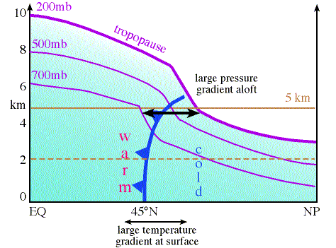
This picture does a good job of showing how cold air will have lower pressure than warm air aloft.
Edit: I should mention, fronts and jet streaks are kinda a chicken and egg scenarios. They each cause each other to some degree.